Environmental Modification Techniques (ENMOD) and the Turkey-Syria Earthquake: An Expert Investigation is Required
All Global Research articles can be read in 51 languages by activating the “Translate Website” drop down menu below the author’s name as well as on the top banner (Desktop version).
Visit and follow us on Instagram at @crg_globalresearch.
Minor Editing, February 28, 2023
Click here to read this article in Turkish. (bu makaleyi türkçe oku)
.
Destruction, social devastation and the loss of life. Our thoughts are with the people of Turkey and Syria.
Introduction
.
The latest reports point to a death toll in Turkey and Syria well in excess of 50,000, more than half a million injured, tens of thousands of people missing. The social devastation and destruction is beyond description. The first and second earthquakes on February 6, 2023 in Kahramanmaras province in Southern Turkey were respectively of the magnitude of 7.6 and 7.8 (Richter scale).
A third earthquake of a magnitude of 6.3 was recorded on February 20th.
In Turkey, some 530,000 people have been evacuated from the disaster area. Ankara confirms that “173,000 buildings have so far been recorded as collapsed or severely damaged, with more than 1.9 million people taking refuge in temporary shelters or hotels and public facilities.”
In the words of President Recep Tayyip Erdogan: ““We are living through the most painful days in our history”.
In Syria, the earthquakes have largely affected the cities of Aleppo, Lattakia and Hama which are within proximity of Syria’s Northwestern border with Turkey. The latest announced death toll in Syria was 5,914, with 8.8 million people affected.
President Bachar Al Assad underscored that US-NATO has been at war with Syria for almost 12 years, while emphasizing that “Syria has not been an earthquake area for about two and a half centuries”.
In this article, Part I will focus on the History of Earthquake Activity in Turkey, while underscoring the fact that prior to the February 6, 2023 earthquake, there was no recent evidence or historical record of “major earthquake” activity in Southern Anatolia.
Part II will provide a Review of Environmental Modification Techniques (ENMOD).
Part III will focus on The Convention on the Prohibition of Military or Any Other Hostile Use of Environmental Modification Techniques, ratified in 1977 by the UN General Assembly.
What is significant in regards to the Turkey-Syria earthquake disaster is that the 1977 UN Convention (cited above) contains provisions for the conduct of an investigation in regards to “destruction, damage or injury” incurred by the “State Parties”, under the auspices of a UN “Consultative Committee of Experts”.
There are also provisions in the Convention for referral to the United Nations Security Council on behalf of the “State Parties”. These issues are outlined in Part IV.
I
History of Earthquake Activity in Turkey
In regards to Turkey, geological analysis suggests the following:
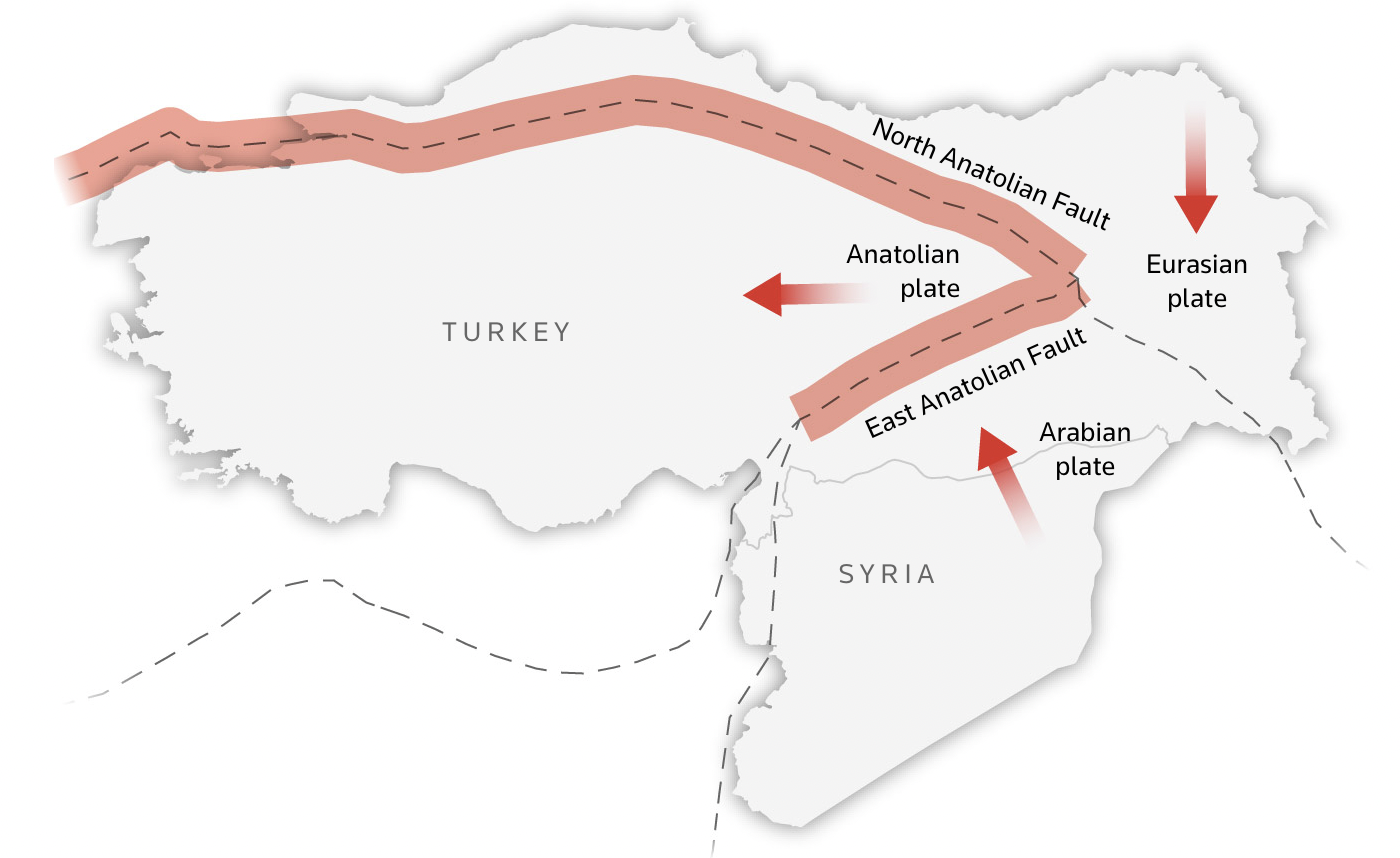
“earthquake activities mainly occur “on the Anatolian plate, a small wedge-shaped tectonic plate that is being squeezed westwards as the Arabian plate to the east slams into the Eurasian plate“. (emphasis added).
What characterizes Turkey’s earthquake activity is:
“a sequence along the North Anatolian Fault that started in 1939, causing large earthquakes that moved progressively from east to west over a period of 60 years”
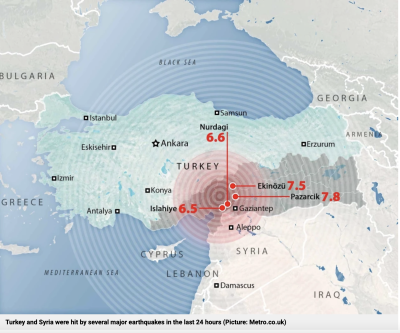
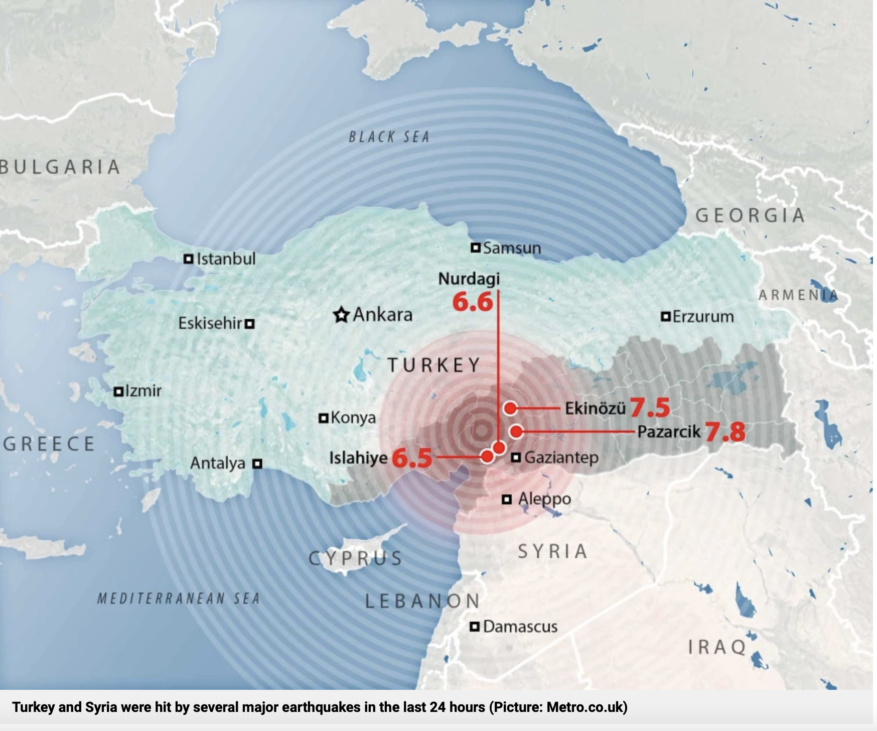
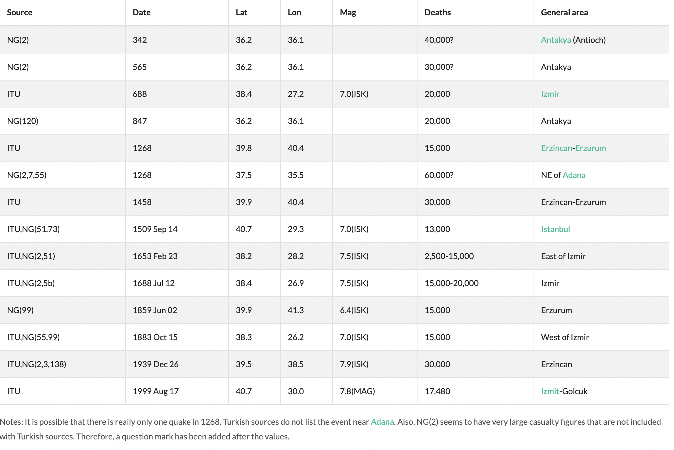
The February 6, 2023 earthquakes with epicentres in Pazarcik (7.8) and Ekinozu (7.5) respectively in proximity of Gaziantep and Kahramanmaraş are the largest “major earthquakes” in recent history. (See Table in Annex, Graph below).
On February 6, around 4:15 a.m. local time, a magnitude 7.8 earthquake struck south-central Turkey near the Turkey/Syria border. Just 11 minutes later, a magnitude 6.7 aftershock shook the region. Nine hours later a magnitude 7.5 quake followed. (USGS – National Earthquake Information Center)
The Map Below identifies the epicentres of the February 6, 2023 earthquakes, located in the South, within proximity of Syria’s Northwestern border.
Epicentre of Ekinozu, Pazarcik earthquakes, February 6, 2023
Recent “Major Earthquakes”
Historically, the largest earthquakes in Turkey have epicentres in North Western Anatolia, in proximity of Istanbul, Western Anatolia as well as in the Northeastern region.
The North Anatolian Fault
Seven large (MS) 7.0 earthquakes in the period from 1939 through 1999 along the North Anatolian Fault. See map above
These earthquakes have ruptured the fault progressively from east to west. Following are data for the seven large earthquakes that have progressively ruptured the North Anatolian fault:
- 1939 December 26. Magnitude (MS) 7.9 – 8.0. 30,000 deaths. Fault length about 360 km. Initiated the eastward migration of significant earthquakes on the North Anatolian fault. (Termed the 1939 Erzincan earthquake, North Anatolia)
- 1942 December 20. Magnitude (MS) 7.1. Fault length about 50 km. (Termed the 1942 Erbaa earthquake, North Anatolia)
- 1943 November 26. Magnitude (MS) 7.6. Fault length about 280 km. (Termed the 1943 Tosya earthquake, Northern Anatolia)
- 1944 February 01. Magnitude (MS) 7.3. Fault length about 165 km. (Termed the 1944 Bolu-Gerede earthquake, Northern Anatolia)
- 1957 May 26. Magnitude (MS) about 7. Fault length about 30 km. (Termed the 1957 Abant earthquake, Northern Anatolia)
- 1967 July 22. Magnitude (MS) 7.1. Fault length about 80 km. (Termed the 1967 Mudurnu Valley earthquake, Northern Anatolia)
- 1999 August 17. Ismit. Magnitude (MS) 7.8; MW 7.4-7.5) North Western Anatolia
Below are the reports of the 5 largest earthquakes since 1950 all of which are along the North Anatolian Fault
Bingol: a magnitude 6.9 and occurred in the eastern city of Turkey on May 22, 1971.
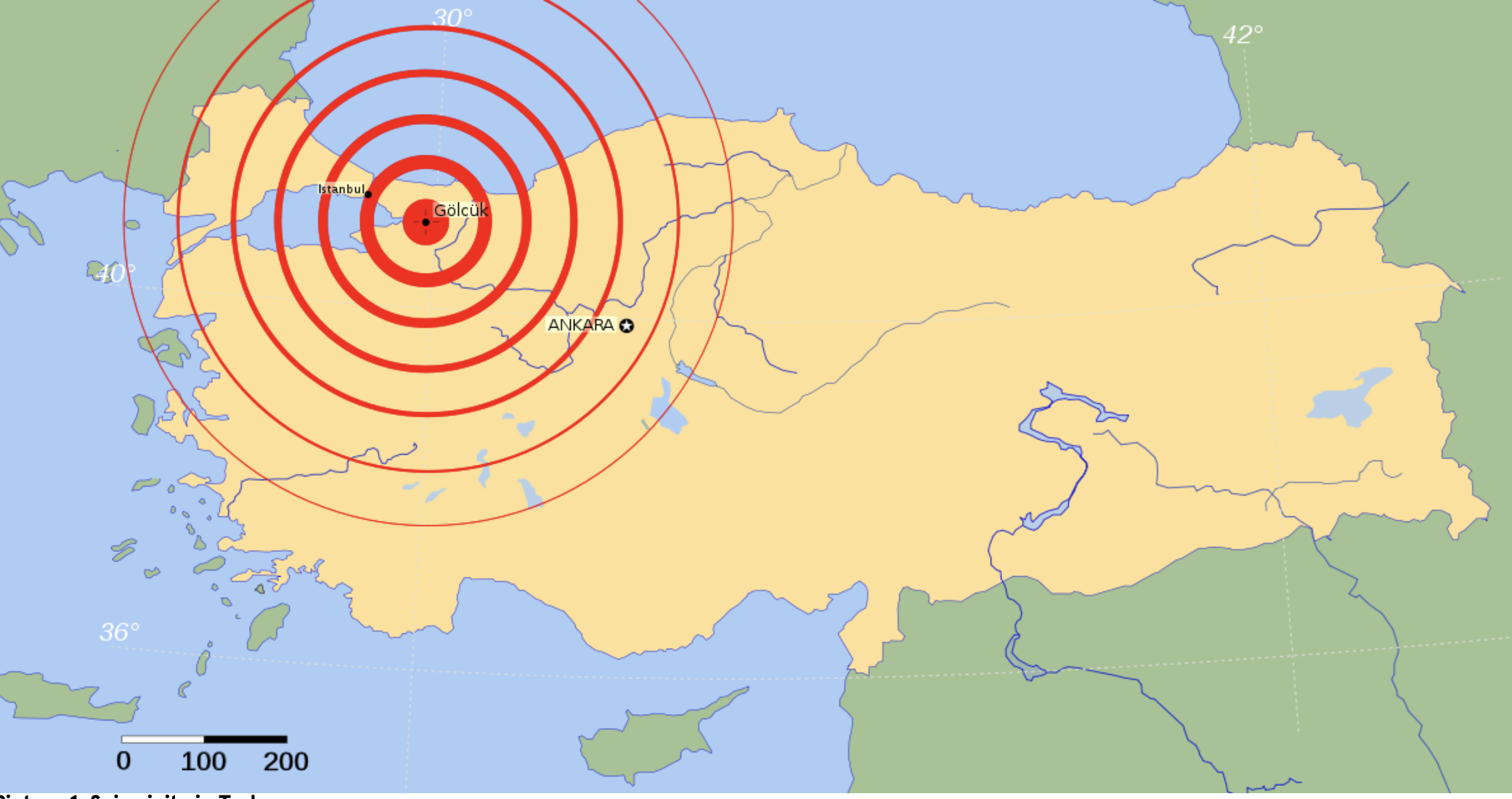
City of Izmit: August 17, 1999, 90 km southeast of Istanbul, 7.6 magnitude. The earthquake occurred in the industrialized and most densely populated urban areas of Istanbul, Sakarya, Golcuk, Darica, and Derince.
Düzce Quake, 12 November 1999, A major earthquake occurred 70 kilometers (45 miles) east of Adapazari or 170 km (105 mi) northwest of Ankara, A magnitude of 7.2.
The city of Van. 23 October 2011. A magnitude 7.1 earthquake, northeastern city close to border with Iran.
Izmir: of 30 October 2020, a magnitude 7.0 with an epicentre about 14 km northeast of the Greek island of Samos
epicentre of Izmit-Golcuk earthquake in Northwestern Anatolia
Nota Bene: None of these major earthquakes (1939-1999) are in Southern Anatolia.
Long-Term History of Earthquakes in Turkey (342 AD -1999)
The history of “major earthquakes” is on record since 342 AD based on data compiled by the USGS – National Earthquake Information Center (See Table in Annex).
In the 13th Century, a “major earthquake” (60,000 deaths) was recorded in Adana in 1268 (Southern Anatolia). Moreover, since the 15th Century, all “major earthquakes” have occurred in Northwestern, Western and Northeastern Anatolia. (See Annex)
Southern Turkey Earthquakes
Reuters has categorized the initial major earthquake (February 6, 2023) “as the most powerful in the region in at least a century”. That is an understatement. In regards to Southern Anatolia, it is the largest earthquake in more than seven centuries. (Adana in 1268, see Table in Annex)
On record in Southern Turkey, is the Ceyhan-Adana earthquake on 27 June 1998, with magnitude of 6.3, affecting the cities of Ceyhan and Adana, 146 deaths. The Ceyan earthquake, however, is not categorized as “a major earthquake”.
As outlined above, the major earthquakes in Turkey are along the North Anatolia Fault.
Prior to February 6, 2023
Not a single “major earthquake” in Southern Anatolia in the course of more than 700 years: Does that not “tell us something” regarding the “probability” or “likelihood” of a “major earthquake” occurring in Southern Turkey?
Earthquake “Forecasting”
Earthquake forecasting is routine. An earthquake can be forecasted up to months ahead. “Forecasting” however must not be confused with “seismological prediction”:
Dutch seismologist Frank Hoogerbeets, who works for the Solar System Geometry Survey (SSGS) in the Netherlands, predicted the earthquake in Turkey on February 3, 2023, three days before its occurrence.
No Firm Evidence of a Terrorist Attack
While there may be doubts at a political level, there is at this stage no firm evidence that this was a terrorist attack. Based on information in the public domaine (as opposed to classified information), there is no tangible evidence that “environmental modifications techniques” were used against Turkey and Syria.
Of significance, however, there was an unofficial statement (yet to be confirmed) by Serdar Hussein, the Head of the Turkish Space Agency in an interview on Russian TV. He referred to hard titanium alloy rods sending powerful beams of energy to earth, deep into the ground.
Below is the translation of his interview.
Transcript (Translation)
The head of the Turkish Space Agency, Serdar Hussein Yildirim, on weapons capable of causing earthquakes:
You know those power poles on the streets. They are similar to these pillars, about 8-10 meters high. Metal rods.
There is nothing inside the rod, no explosives, nothing, but it’s a metal rod made of a hard titanium alloy material.
They put them in a satellite. And then they aim and launch them to Earth. It’s like a stick with a sharp point. For example, God forbid, it falls somewhere, we will not name the disaster scenario now, but as soon as it falls to the ground, it penetrates up to 5 km deep into the earth.
This happens very quickly and creates an earthquake of magnitude 7-8.
As a result of the impact, everything that is there will be destroyed. Look, there are no weapons here, no explosives, no bombs, nothing like that. Simple sticks [rods]. But there is such a force that comes from outer space, and you have no chance to see it, stop it, or defend yourself.” (emphasis added)
II
Environmental Modification Techniques
There is a vast literature on weather modification techniques for military use much of which is classified. The US and Russia are on record. They possess advanced ENMOD technologies.
The US Military can control the weather. This is confirmed by a US Air Force document entitled “Weather as a Force Multiplier: Owning the Weather in 2025“
The late World renowned scientist Dr. Rosalie Bertell confirmed that “US military scientists … are working on weather systems as a potential weapon. Already in the 1970s, former National Security advisor Zbigniew Brzezinski had foreseen in his book “Between Two Ages” that:
“Technology will make available, to the leaders of major nations, techniques for conducting secret warfare, of which only a bare minimum of the security forces need be appraised…”
Scientist Dr. Nicholas Begich who was actively involved in the public campaign against HAARP– described HAARP as:
“A super-powerful radiowave-beaming technology that lifts areas of the ionosphere [upper layer of the atmosphere] by focusing a beam and heating those areas. Electromagnetic waves then bounce back onto earth and penetrate everything — living and dead.”
Marc Filterman, a former French military officer, outlines several types of “unconventional weapons” using radio frequencies. He refers to “weather war,” indicating that the U.S. and the Soviet Union had already
“mastered the know-how needed to unleash sudden climate changes (hurricanes, drought) in the early 1980s.”
My article entitled Weather Warfare first published by The Ecologist on May 22 2008 provides a summary of several in-depth and detailed articles I wrote at an earlier period on environmental modification (ENMOD) techniques for military use:
“Rosalie Bertell, president of the International Institute of Concern for Public Health, says HAARP operates as ‘a gigantic heater that can cause major disruptions in the ionosphere, creating not just holes, but long incisions in the protective layer that keeps deadly radiation from bombarding the planet’.
Physicist Dr Bernard Eastlund called it ‘the largest ionospheric heater ever built’.
HAARP is presented by the US Air Force as a research programme, but military documents confirm its main objective is to ‘induce ionospheric modifications’ with a view to altering weather patterns and disrupting communications and radar.
The CBC Documentary on HAARP
Of significance, a CBC TV report (1996) acknowledged that the HAARP facility in Alaska under the auspices of the US Air Force had the ability of triggering typhoons, earthquakes, floods and droughts:
“Directed energy is such a powerful technology it could be used to heat the ionosphere to turn weather into a weapon of war. Imagine using a flood to destroy a city or tornadoes to decimate an approaching army in the desert. The military has spent a huge amount of time on weather modification as a concept for battle environments. If an electromagnetic pulse went off over a city, basically all the electronic things in your home would wink and go out, and they would be permanently destroyed.”
CBC TV Report (1996)
It should be noted that while the HAARP program based in Gakona, Alaska was closed down in 2014 (transferred to the University of Alaska), the US Air Force which managed the HAARP project, nonetheless confirmed that ENMOD techniques for military use were slated to continue:
“We’re moving on to other ways of managing the ionosphere, which the HAARP was really designed to do,” he said.
“To inject energy into the ionosphere to be able to actually control it. But that work has been completed.”
“Weather as a Force Multiplier: Owning the Weather”
The underlying objective from a military standpoint is “Owning the Weather”. At the time this US Air Force study was commissioned in 1996, the HAARP program was already fully operational as documented by the CBC.
The stated purpose of the Report is described below:
In this paper we show that appropriate application of weather-modification can provide battlespace dominance to a degree never before imagined. In the future, such operations will enhance air and space superiority and provide new options for battlespace shaping and battlespace awareness there, waiting for us to pull it all together;” in 2025 we can “Own the Weather.” (Commissioned by US Air Force document AF 2025 Final Report, (public document)
Weather-modification, according to the US Air Force Report “offers the war fighter a wide range of possible options to defeat or coerce an adversary”, capabilities, it says, extend to the triggering of floods, hurricanes, droughts and earthquakes:
‘Weather modification will become a part of domestic and international security and could be done unilaterally… It could have offensive and defensive applications and even be used for deterrence purposes. The ability to generate precipitation, fog and storms on earth or to modify space weather… and the production of artificial weather all are a part of an integrated set of [military] technologies.”
US Air Force document AF 2025 Final Report, (original AF document link no longer available)
See complete reports commissioned by the US Air Force
….From enhancing friendly operations or disrupting those of the enemy via small-scale tailoring of natural weather patterns to complete dominance of global communications and counterspace control, weather-modification offers the war fighter a wide-range of possible options to defeat or coerce an adversary. Some of the potential capabilities a weather-modification system could provide to a war-fighting commander in chief (CINC) are listed in table 1. (emphasis added)
While the triggering of earthquakes is an integral part of the HAARP technology, the term earthquakes does not appear explicitly in the above version of US Air Force document. Appendices A and B of the report point to role of the Ionosphere pertaining to maximum usable frequency (MUF).
The Involvement of the CIA in ENMOD Technologies
Back in July 2013, MSN news reported that the CIA was involved in helping to fund a project by the National Academy of Sciences (NAS) focusing on geo-engineering and climate manipulation. The report not only acknowledged these technologies, it confirmed that US intelligence has been routinely involved in addressing the issue of climatic manipulation:
“The goal of the CIA-backed NAS study is to conduct a “technical evaluation of a limited number of proposed geoengineering techniques,” according to the NAS website. Scientists will attempt to determine which geoengineering techniques are feasible and try to evaluate the impacts and risks of each (including “national security concerns”).” (See Slate, July 2013)
“The CIA is helping fund the research because the NAS also plans to evaluate “the national security concerns (that could be) related to geoengineering technologies being deployed somewhere in the world,” Kearney said.
.
III
The 1977 U.N. Convention
on the Use of Environmental Modification Techniques
.
The historic 1977 Convention ratified by the UN General Assembly banning “military or other hostile use of environmental modification techniques having widespread, long-lasting or severe effects.”

….Each State Party to this Convention undertakes not to engage in military … use of environmental modification techniques having widespread, long-lasting or severe effects as the means of destruction, damage or injury to any other State Party. (Convention on the Prohibition of Military or Any Other Hostile Use of Environmental Modification Techniques, United Nations, Geneva, May 18, 1977. Entered into force: 5 October 1978, see full text of Convention in Annex)
To Read the full text of the UN Convention, click here
The List of countries which have ratified or signed the Treaty
As of 2022, 78 countries have ratified or acceded to the treaty including Syria, Turkey, Iraq, Iran, the U.S. and the Russian Federation. Israel has not ratified the Treaty.
European Parliament Committee’s Motion for Resolution
It is also worth noting that in February 1998, the European Parliament’s Committee on Foreign Affairs, Security and Defense Policy held public hearings in Brussels on the HAARP program. The Committee’s “Motion for Resolution” submitted to the European Parliament:
“Considers HAARP… by virtue of its far-reaching impact on the environment to be a global concern and calls for its legal, ecological and ethical implications to be examined by an international independent body…; [the Committee] regrets the repeated refusal of the United States Administration… to give evidence to the public hearing …into the environmental and public risks [of] the HAARP program.” (emphasis added)
IV
“An Expert Investigation” into “Hostile Use of ENMOD”
.
In view of the gravity of the Turkey-Syria earthquake, the loss of life, the devastating social and economic impacts, an “expert investigation” should be conducted predicated on the 1977 International Convention banning “military or other hostile use of environmental modification techniques”.
I should mention that since the ratification of the 1977 UN Convention cited above, ENMOD techniques for military use have become increasingly sophisticated.
Can we trust the United Nations? The two “State Parties”, namely Turkey and Syria should collaborate and conduct their own internal investigation prior to the conduct of an expert investigation under UN auspices.
The Terms of Reference of this Investigation are contained in the Articles of Agreement of the UN Treaty.
I will be referring to Article I, II and V (excerpts) which identify the nature of the Expert Investigation. (emphasis added). Click here, to consult the complete list of Articles
Article I. 1.
Each State Party to this Convention undertakes not to engage in military or any other hostile use of environmental modification techniques having widespread, long-lasting or severe effects as the means of destruction, damage or injury to any other State Party.
Article II refers to ENMOD techniques including earthquakes:
Article II
As used in article 1, the term “environmental modification techniques” refers to any technique for changing – through the deliberate manipulation of natural processes – the dynamics, composition or structure of the Earth, including its biota, lithosphere, hydrosphere and atmosphere, or of outer space.
Article V
1. The States Parties to this Convention undertake to consult one another and to co-operate in solving any problems which may arise in relation to the objectives of, or in the application of the provisions of, the Convention. Consultation and co-operation pursuant to this article may also be undertaken through appropriate international procedures within the framework of the United Nations and in accordance with its Charter. These international procedures may include the services of appropriate international organizations, as well as of a Consultative Committee of Experts as provided for in paragraph 2 of this article.
2. For the purposes set forth in paragraph 1 of this article, the Depositary shall within one month of the receipt of a request from any State Party to this Convention, convene a Consultative Committee of Experts. …
3. Any State Party to this Convention which has reason to believe that any other State Party is acting in breach of obligations deriving from the provisions of the Convention may lodge a complaint with the Security Council of the United Nations. Such a complaint should include all relevant information as well as all possible evidence supporting ItS validity.
4. Each State Party to this Convention undertakes to cooperate in carrying out any investigation which the Security Council may initiate, in accordance with the provisions of the Charter of the United Nations, on the basis of the complaint received by the Council. The Security Council shall inform the States Parties of the results of the investigation.
In Annex to the Text of the Convention is the Following:
1. The Consultative Committee of Experts shall undertake to make appropriate findings of fact and provide expert views relevant to any problem raised pursuant to paragraph 1 of article V of this Convention by the State Party requesting the convening of the Committee.
emphasis added
Concluding Remarks
We are in solidarity with the people of Turkey and Syria.
At this stage, it would be unwise and premature to draw simplistic conclusions.
There is a forbidden truth. I have attempted to provide a framework of analysis and understanding.
The damage and loss of life is beyond description: The issue should be the object of analysis, dialogue and debate, with reference to the 1977 International Convention banning “military or other hostile use of environmental modification techniques”.
Turkey and Syria as “State Parties” must, as a first step, conduct their own internal investigation before referring it to the UN Consultative Committee of Experts and/or to the United Nations Security Council.
Annex
Source: This Information was provided by USGS – National Earthquake Information Center
Earthquakes in Turkey that caused 10,000 or more deaths (342 AD- 1999)
The following are the sources and footnotes
ISK: Earthquake catalog of Kandilli Observatory, Bogazici University, Istanbul, supplied by NOAA/NGDC (Meyers and Von Hake), Boulder CO, 1985.
ITU: K. Ergin, U. Guclu and Z. Uz, A Catalog of Earthquakes for Turkey and Surrounding Area (11 AD to 1964 AD), Technical University of Istanbul, Faculty of Mining Engineering, 1967.
AFAD: Earthquake Risk Map by AFAD, Department of Disasters and Emergency Management, 2018.
NG(n): R. Ganse and J. Nelson, Catalog of Significant Earthquakes 2000 BC – 1979 Including Quantitative Casualties and Damage, NOAA/NGDC Report SE-27, Boulder CO, 1981. The number in parentheses is from their references table, as listed below:
2: Lomnitz, Global Tectonics and Earthquake Risk, 1974.
3: Bath, Introduction to Seismology, 1978.
5b: (there is no source 5b — probably should be 55?).
7: Meyers and von Hake, Earthquake data file summary, 1976.
51: Munchener Ruckversicherungs-Gesellschaft, World Map of Natural Hazards, 1978.
55: Milne, Catalogue of Destructive Earthquakes, 1911.
73: U.S. Congress, Great Earthquakes, 1888.
99: Karnik, Seismicity of the European Area, 1971.
120: Alsinawi and Galih, Historical Seismicity of Iraq, 1978.
138: Ambraseys, Middle East A Reappraisal of Seismicity, 1978.


No comments:
Post a Comment